
The Concentric Zone Model of Urban Land Use FOR UGC NET EXAM
The Concentric Zone Model
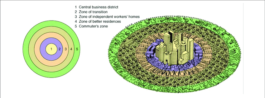
The concentric zone model of urban land use was first proposed by E.W. Burgess (1924, 1927). This is also known as the ‘ecological theory of city structure’, the Bull’s Eye Model, the Concentric Ring Model, Concentric Circles Model.
Burgess’ main research interest was the determinants of urban social problems, such as vice and crime, and his mapping of their occurrence within Chicago indicated a concentration in certain type areas only, but was later seen to have more universal application. Burgess’ model is based on the idea that the growth of a city takes place outwards from its central area to form a series of concentric zone.
Burgess identified a system of five concentric zones, each characterized by a particular type of land use:
Zone I (Central Business District-CBD): CBD occupies the central place and it is the focus of city’s commercial, social and civic life. This part is most readily accessible part of the city as all routes radiate here. The heart of this zone is known as the downtown. It contains departmental stores, smart shop, office buildings, financial institutions, banks, insurance offices, real estate offices, hotels, restaurants, wholesale trade, theatres, recreation places and headquarters of economic, social, civic and political organizations. The land value and rent of space are very high in the CBD.
Zone II (Zone in Transition): This zone surrounds the CBD and it is the zone of residential deterioration. There is invasion of business in this area which led to a decline in residential desirability. Some slums may also develop in this area. There may be some light industries in the inner part of this zone. The owners of property in this zone are not interested in improving the quality of buildings. This area is occupied by lower income groups. They live close to the place of work as they cannot afford high cost of transport.
Zone III (Zone of Independent Workmen’s Home): This zone is made up largely of the homes of factory workers and labourers and these are the people who often moved out of the zone II (zone of transition). In India, generally, this area has planned flats. The density and occupancy of this zone is always high.
Zone IV (Zone of Better Residence): In this zone the majority of the middle and upper-middle class people reside. Small businessmen, professional people, better paid government employees and salesmen reside in this zone. This area is dominated by single families.
Zone V (Commuter’s Zone): Beyond the city proper are located a small number of small towns which are mostly dormitory towns in that most of the people living here commute to the city every day for work. Most of the people living here work in the CBD. Here are large spacious houses usually having their own lawns etc. and are built at some distance from each other. The cost of land is comparatively low.
As stated above, each of the city zone, according to Burgess, has a tendency to expand outward.
Criticism
- The Burgess’ model suggests a circular shape of the CBD. The CBDs are generally either square, rectangular or linear and not necessarily circular in shape.
- There is overemphasis on commerce and trade activity and a complete neglect of the industrial land use.
- The outward expansion of the Zone I into Zone III has not been explained. In fact, how the lower income group people can encroach the outer space of Zone III occupied by rich people
- The effect of major transport has been ignored. People prefer to stay close to the roads. Consequently, the space along the roads has high valuation and high rent value.
- The topographical factors have also been ignored. Concentric zones are not possible in the areas of undulating topography and the cities located near lakes, rivers and other water bodies.
Summary of Concentric Zone Model Theory:
- Concentric Zone Model Theory:E.W. Burgess
- Postulated– 1920s (1924,1927)
- Model Based-Chicago City (America)
- 5 Zones:
I. Central Business District :
* Down town area,
* Non-residential center,
* Focus on business and commerce,
* Residents of outer zones commuted to this zone,
* Land value and rent very high.
II. Zone in Transition:
* Zone of residential deterioration,
* Slums area found,
* Poor housing and infrastructure.
III. Zone of Independent Workmen’s Home:
* Working class families,
* People can afford to move Zone 2 (Zone in Transition).
IV. Zone of Better Residence:
* Middle, upper-middle class people reside,
* Well educated single families.
V. Commuter’s Zone:
* Maximum upper class people,
* Commute everday in Zone 1 (Central Business District) for work/recreational purpose.
Links of Urban Land Use Models:
1. Concentric Zone Model by E.W Burgess
2. Wedge/Sectoral Model by Homer Hoyt and M.R.Davis
3.Multiple Nuclei Model by C.D Harris and E.D Ullman
4.Pre.asked question on Urban Land Use in NTA & CBSE UGC NET